Adur Weather 2010

Link to the Shoreham Weather Reports for 2009
26
December 2010
Just
after midnight, a temperature of minus 6.1
°C was recorded at 1:00
am, but then the temperature rose steadily
reaching plus 5.6 °C at 11:00
pm.
25
December 2010
It
was the coldest Christmas Day since
I remember, with an air temperature at 7:00
am at minus 2.2
°C, with the Gentle Breeze (Force
3) that blew from the
north at 10 m.p.h.
The
air temperature stayed below freezing throughout the daylight hours falling
to minus 3.1 °C at
9:00
pm.
18
December 2010
There
is a sprinkling of snow in the morning and drizzly rain during the day,
but in other parts of the south-east of England there were substantial
(10+ cm) falls
of snow.
9 -
10 December 2010
The
overnight temperatures kept above freezing falling to a low of 0.2
°C. The wind direction was changeable
(from all directions except from the south) veering from north to east
within an hour around dawn and then to west in the following hour.
9 December
2010
Early
morning temperatures were minus
2.0 °C and below, but temperatures rose
above freezing during the daylight hours. Despite this, my small garden
pond remained frozen over and could not be broken with a rake.
6 -
7 December 2010
It
was just below freezing for the whole of both days and nights with the
Breeze (Force 3)
from the north.
4 December
2010
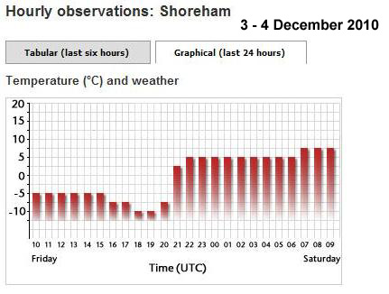
At
9:00 am all the snow had melted and it was
raining slightly with the 10 mph
Breeze (Force 3)
from the WSW
and an air temperature of 7.3 °C.
At midnight of the third into the fourth the weather had changed dramatically and the SSW wind could be heard whistling through the houses recorded at steady Strong Breeze (Force 6) gusting to Gale Force 7 (38 mph). The air temperature had risen further to 4.8 °C. The snow was still at depth of 150 mm in my front garden.
3
December 2010
By
9:00 pm the wind direction had dramatically
switched to SSW
at a steady
17 mph
(Force 3)
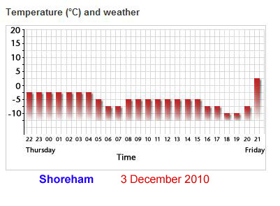
the temperature had changed within an hour from minus
7.4 °C at
8:00
pm to plus
3.6 °C, an unprecedented change. A
quick look outside and it does seem that the wind has increased but it
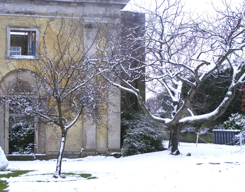
was still cold outside, the snow was not melting and the ground seemed
to be frozen.
At
7:00
pm the air temperature had fallen further
to minus 9.7 °C. The
wind had receded to negligible (1 mph)
from the north.
At
6:00
pm the air temperature
had fallen further to minus
9.5 °C, the lowest temperature recorded
since February
1983.
At
5:00
pm the air temperature had fallen further
to minus 8.4 °C, the
lowest temperature recorded this millennium by 1.1°C.
The
wind speed from the north was only 2 mph.
The highest temperature recorded during the day (lowest maximum) was minus
4.4°C.
 |
 |
At
6:00
am the air temperature
fell to an over night low of minus 6.3
°C,
the second lowest temperature
recorded this millennium. An hour later it fell to minus
6.7 °C which was only
0.6 °C above the previous Lowest
Temperature this Millennium. The Light
Breeze (Force 2)
blew from the north. After midday, mist obscured the views of Lancing College
and Mil Hill from the Adur
Levels. There was low lying mist
over the River Adur despite the low tide.
Mist occurs with cold air over warmer water.
Met
Office: Shoreham
2 December
2010
Snow
fell over night in a Gentle Breeze (Force
3) that blew in from the
NNE at 8 m.p.h.
The
pavement depth of snow was measured at
155
mm at 10.00 am.
The air temperature at 8:00 am
was minus 3.8 °C. A
Gentle Breeze (Force
3) blew from the
NNE at 8 m.p.h.
 |
 |
Mill Hill
On
the west-facing slopes of Mill Hill the
snow depth was measured at 190 mm
and in areas exposed to the north-easterlies the average depth could reach
230
mm.
 |
The weather vane on the top of the parish church of St. Mary de Haura points to the north-east. |
1 December
2010
A
light shower of snow fell in the morning. Then air temperature at 10:00
am was minus
1.4 °C. A Moderate Breeze (Force
4) blew from the NNE at 13
m.p.h. which indicates a wind
chill of nearly minus 11°C (new readings,
the old method recorded minus 7°C). The
pavement depth of snow was measured at 30
mm at 1:30 pm.
More snow fell in the late evening before midnight. The pavement depth
of snow was measured at 110 mm
at 11:30 pm. At
midnight the air temperature fell to minus
3.5 °C.
Met
Office: Shoreham
29
November 2010
An
air temperature of minus 3.6 °C
was recorded at 7:00 am.
Met
Office: Shoreham
28
November 2010
An
air temperature of minus 3.7 °C
was recorded at 8:00 am. A
Moderate Breeze (Force
4) blew from the north at 15
m.p.h. which indicates a wind
chill of nearly minus 11°C (new readings,
the old method recorded minus 7°C).
Met
Office: Shoreham
26
November 2010
An
air temperature of minus 2.7 °C
was recorded at 7:00 am.
A Gentle Breeze (Force
3) blew from the north at 8
m.p.h.
Met
Office: Shoreham
 11
November 2010
A
Force
5 blew steadily through the daylight hours
from SSW, regularly
gusting to Gale Force 7
and this could be seen on the sea with large waves forming and whitecaps
everywhere (indicative of a Force 6).
Met
Office: Shoreham
21-22
August 2010
Rain
and cloudy weather conditions over the two days of the Shoreham Air Show
was unusual and may have put a dampener on the butterflies
for the rest of the year.
14
March 2010
The
sun shined weakly and an air temperature of 21.1
°C was recorded at 2:00
pm, the warmest so far this year.
Met
Office: Shoreham
7 March
2010
Ice
froze over the Common Frog spawn in
my garden pond overnight as the air temperature fell to a low of minus
2.9 °C
at 7:00 am (the
lowest temperature in the south-east of England). During the day the temperature
well above freezing, but the thin layer of ice remained in my north facing
garden, until I broke the ice around the spawn.
10
February 2010
In
the morning it
tried to snow but it was after dusk
before a very small smattering of snow laid on the ground, the breeze (Force
4) came from due north and the air temperature
fell below freezing.
January
2010
It
was the coldest January since 1987.
Met
Office Climate Statistics
Met
Office January 2010
14
January 2010
The
snow and ice had disappeared on the roof tiles and pavements outside of
my house in Shoreham.
13
January 2010
 |
 |
 |
|
|
|
|
Much of the loose packed snow melted quickly to slush by the early afternoon. There was a steady drip from the evergreen and for trees on which the snow had landed. After dusk, the temperature rose and by midnight almost all the snow had turned to slush.
12
January 2010
A
thin layer of snow laid over night, replacing the melted snow of the previous
day. It was deeper than it first appeared, measured at 35
mm on the pavement outside my house in Shoreham.
The night and day air temperature was fractionally above freezing.
11
January 2010
The
thaw continued but with temperatures just above freezing (>
1.4 °C) throughout the day, a small impact
was made on accumulated snow on the pavements and side roads. Widewater
Lagoon was only partly frozen with large areas (75%) of open water.
Met
Office: Shoreham
10
January 2010
The
temperature rose just above freezing and the snow over my garden pond melted.
Some snow on the pavements melted and there was a general dampness in the
air. By the afternoon, the side roads had turned to slush and the main
roads were clear.
9 January
2010
Further
snow fell in the morning reaching an accumulated depth of 20
mm on the Shoreham pavements. The temperature
fell to minus 3.1 °C
at 7:00 am. The
wind was blowing partly from the west so where no snow landed in places
sheltered from the east winds before (notably the twitten between Corbyn
Crescent and Adelaide Square in Shoreham, which was previously bare of
snow), there was now a notable layer of a a few millimetres.
 |
 |
 |
On
Mill
Hill it was difficult to gauge the depth of snow because of drifting,
but it was measured at 120 mm.
With the early afternoon northerly winds at a Moderate Breeze (Force
5) small ground
blizzard conditions were created on the New Erringham pastures as the
powdery snow was blown from the north-east. The temperature remained
just below freezing for most of the day. Snow lay on the ice of my pond
in my garden.
Adur
Teasels
 8
January 2010
A
clear sky should have resulted in temperatures plummeting as it did
elsewhere
in Britain, but the lowest over night temperature was minus
2.0 °C. The saline Widewater Lagoon was
frozen over with a very thin layer of ice; a cobble-sized stone thrown
in would go though the ice, which was strong enough to support over thirty
Black-headed
Gulls. The central area of the lagoon, east
of the bridge, was ice-free.
Adur
Coastal 2010
7
January 2010
Awakening
in the morning, looking through the gaps in the houses from my front window,
on a clear day, I could see the snow was still appreciable on the downs
pastures of New Erringham. At 9:00
am the air temperature
fell to an over night low of minus
6.1 °C, the equal second lowest temperature
recorded this millennium. The temperature rose throughout the day but still
remained well below freezing with a negligible wind. The snow depth was
a measured 25
mm on the pavements
in Shoreham at first light.
 |
 |
 |
|
|
|
|
Later
in the morning I visited Lancing Ring
where the snow was much deeper in the meadows and adjoining fields and
the average was measured at 95 mm drifting
to three times that depth. The
snow on the east side of the trees indicated the direction of the wind
during the snowfalls.
Met
Office: Shoreham
Lowest
Temperature this Millennium

 6
January 2010
A
steady flurry of light snow blew in from the east in a Moderate Breeze
(Force 5)
but the air temperature remained just above freezing. The ground temperature
must have been lower as the duration of the snowfall lasted for hours in
the morning and a small amount of snow to 8
mm laid on the pavements of Shoreham. The
downs
and countryside were covered to a similar depth, but in places this quickly
turned to slush. Pastures and arable fields were more sparsely covered,
negligible in lots of places. About midday,
the light snowfalls turned to sleet.
After dusk there
was a further snowfall of a few millimetres which stopped before midnight.
The temperature fell below freezing (minus
1.9 °C at 11:00
pm).
 5
January 2010
The
air temperature fell to minus 6.1 °C at
at
6:00
am, the lowest temperature this winter and
the second lowest this millennium.
The
wind was negligible.
Met
Office: Shoreham
Lowest
Temperature this Millennium
4 January
2010
There
was frost on the ground and an air temperature of minus
3.9 °C at 8:00
am.
Selected
weather reports for 2009