 Wind
Chill Calculator
Adur
Weather 2011
- 2023
and Geological
Events

Maximum UK Recorded Air Temperatures
List of Cloud Types (Wikipedia)
Surf Report for Shoreham (Magic Seaweed)
Past Severe Weather (Met Office)
Storm
Surges
Storm
Surges for Newhaven (Forecasts)
Storm
Surges (Met Office)
Chart Datum ° Ordnance Datum (Differences at selected UK and Irish ports)
Link to the Shoreham Weather Reports for 2010
30
July 2024
The
air temperature reached 28.2°C
by midday.
Met
Office Shoreham
9 October
2023
Sunny
21°C.
8 October
2023
Sunny
21°C.
3 October
2023
Sunny
and pleasant, 19°C
1 October
2023
Sunny
and pleasant, 21°C
at 2 pm, warm
for October.
10
September 2023
26°C
at
11:00 am.
9 September
2023
27°C
at
midday
8 September
2023
Hazy
sun, Force 1. 26°C
7 September
2023
The
light wind (Force 3) switched to from the north and the air temperature
peaked at 26°C
5 September
2023
On
a sunny day, the highest air temperature of the year of 29°C
was attained at 2 pm. Met
Office Shoreham. This was the highest temperature since last
year.
4 September
2023
Sunny
and warm and dry again. It was 28°C
at 3 pm, 4 pm and 5 pm. Met
Office Shoreham. This was the equal highest of the year.
18
June 2023
Thunder
& lightning for two hours from midnight.
16
June 2023
Sunny
and warm and calm and dry again. It was 24°C
at 11 am. Met
Office Shoreham
15
June 2023
Sunny
and warm and calm and dry again. It was 25°C
at 11 am. Met
Office Shoreham
14
June 2023
Sunny
and warm and dry again. It was 26°C
at midday. Met
Office Shoreham
13
June 2023
Another
sunny warm day from late morning to afternoon reaching the highest of the
year of 28°C at
5 pm. Met
Office Shoreham
11
June 2023
Another
warm day from morning to afternoon attaining 24°C.
10
June 2023
Another
warm day from morning to late afternoon attaining 25°C
at
10 am and 3 pm and 6 pm. Met
Office Shoreham A few white clouds but no signs of rain.
9 June
2023
Late
in the afternoon the air temperature reached a humid 26.1°C.
Met
Office Shoreham recorded 26°C at
4 pm.
7 June
2023
The
warmest day of the year with the late afternoon temperature in the sun
attaining a pleasant 22°C.
1 November
2022
Midnight
Halloween, Force 11 wind gusts
measured by the Met
Office Shoreham at 68 mph
at 2:00 am.
14
August 2022
The
Met
Office (Shoreham) shade air temperature
attained 29°C
at 11 am. Windfinder
recorded 30°C
at 10:50 am.
13
August 2022
The
Met
Office (Shoreham) shade air temperature
attained 29°C
at 5 pm.
12
August 2022
The
Met
Office (Shoreham) shade air temperature
attained 30°C
at 11 am.
4 August
2022
Everywhere
was parched and very dry to an unprecedented extent with many flowers.fading
on their stems with a paucity of insect visitors.
27
July 2022
Harvest at Old Erringham
It
was a record breaking heatwave,
the
Met
Office (Shoreham) shade air temperature
attained 32°C at
1
pm., the highest recorded temperature this
century, beating the previous record in 2020
by 1°C.
The
air temperature reached 33°C at
5
pm.
It
was alarmingly sunny and warm, the
Met
Office (Shoreham) shade air temperature
attained 26°C
at
3
pm.
Windfinder
recorded 29°C.
18
February 2022
Storm
Eunice
The
wind gust of 70.19 mph was exceptional and the highest on these
weather pages probably greater than
February 2014
9 August
2021
Rain
with torrential showers and a south-west breeze,16
°C. It had stopped by the afternoon.
7 February
2021
A
minimal layer of snow settled in Shoreham and on the downs and did not
melt.
Mill
Hill
Photograph
by Sylvia Lemoniates
facebook
27 December 2020

16
August 2020
There
was a five minute shower of heavy rain
and
a rumble of
thunder at
1:45
pm.
12
August 2020
A
rumble
of thunder was first heard at 11:48
pm. Two faint rumbles was all I heard.
11
August 2020
The
Met
Office (Shoreham) shade air temperature
attained an unpleasantly hot 31.0 °C
at
midday.
9 August 2020
The Met Office (Shoreham) shade air temperature attained an unpleasantly hot 33.0 °C at 3:00 pm and 4:00 pm, the highest temperature this century.
25 June 2020
The highest air temperature recorded by Met Office (Shoreham) was 29.0 °C at 2:00 pm & 3:00 pm.
24
June 2020
It
was getting seriously too warm and even the wild
flowers were beginning to wilt after the
long dry spell of nearly two months.
It
was the warmest day of the year
with the highest air temperature recorded by Met
Office (Shoreham) of 29.0
°C at
3:00
pm. Accuweather
recorded 30.0
°C (This
could be the second highest temperature this
century?)
May
2020
Nationally,
it was the sunniest May
on record.
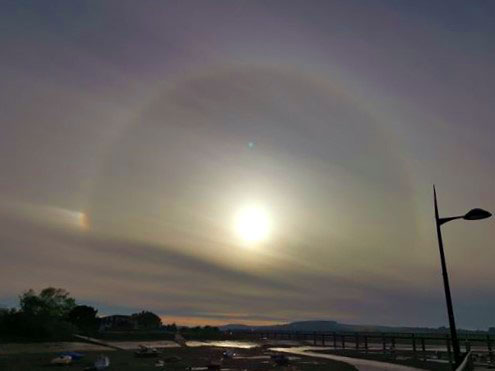 |
22
May 2020
Sundog Photograph
by Stevie Lilac Retfalvy
Sun Dogs are a member of a large family of halos, created by light interacting with ice crystals in the atmosphere. Sun dogs typically appear as two subtly coloured patches of light to the left and right of the Sun, approximately 22° distant and at the same elevation above the horizon as the Sun. They can be seen anywhere in the world during any season, but they are not always obvious or bright. Sun Dogs are best seen and are most conspicuous when the Sun is close to the horizon.
|
8 May 2020
Kingston
Sunset by Sylvia Lemoniates
facebook
29
March 2020
Most
people were indoors for the brief afternoon hail
lasting an estimated three minutes.
29
February 2020
A
gust of wind exceeded 50 mph (Gale Force
9).
26
February 2020
The
first sleet
of the decade rained down for a couple of minutes in the afternoon.
9 February 2020
Storm Ciara. Gales blew all day from before dawn to after dusk, often with rain. At 7:00 pm, a wind gust of 60.99 mph (Storm Force 10) was recorded by Windfinder.
8 February
2020
The
Full
Moon was due north in the late afternoon.
6 February 2020
It was a mild January 2020, but the air temperature fell just below freezing at half at dawn, falling to its lowest point at half an hour after sunrise. The Waxing Gibbous Moon could be seen in the east in the afternoon blue sky.
20 January 2020
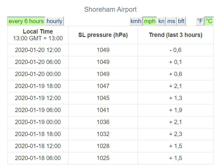
The air pressure has levelled out to 1049.0 at midnight and the figure of 1050 mbs was not attained at Shoreham Airport registering a slight fall to 1048.9 at 1:00 pm. The last time the figure exceeded 1050 was in 1957 in County Mayo, Ireland and Benbecula, Scotland at 1050.9, and the time before that was in 1932.
Afternoon Cloud
I identified the afternoon cloud as nearest to a high altitude Altocumulus undatus or 'Mackerel Sky'.
19
January 2020
The
barometer
read 31 inches
at 9:00 pm which
equals 1049.78 millibars (not precise
enough).
This
is an exceptionally high reading on the Fair/Very Dry scale. Mumbles,
Swansea, recorded the highest reading at 1050.5 mbs.
 |
.jpg) |
Weather
Online
How
to Read a Barometer
Weather
Conversion Calculator
The
Met
Office recorded 1049 hPa
at 10:00 pm.
Humidity recorded at 90%.
The
weather
was cold (2 °C
in the evening) and clear (no clouds) all day.
A south-moving
jet
stream has pushed a pocket of extremely high atmospheric pressure towards
the UK. The gauges will likely be pushed above 1,050 hectopascals (hPa),
meaning the highest reading in decades. The Exeter-based Met Office expects
it to surpass the recent record of 1049.2 measured in 1992.
Devon
Live Report
The all-time English record, set in 1902, is 1053 millibars. (hPa is the same as millibars, mbs.)
A line on a weather map is an isobar, a line which connects points of equal atmospheric pressure.
2 November 2019
It
was atrocious weather with a steady gale blowing with gusts to Force
11, and constant heavy rain all day.
Windfinder
Met
Office (Shoreham)
High Tide 5.7 metres
Storm
Surges
Storm
Surges for Newhaven (Forecasts)
26
August 2019
A
very humid and warm day, recorded a maximum air temperature of 26.0
°C at 11:00
am with little or no wind (Force
2) under a clear blue sky, above 24.0
°C thereafter until 6:00
pm.
Met
Office (Shoreham)
25
August 2019 (Bank Holiday Monday)
The
Met
Office (Shoreham) recorded a maximum air
temperature of 23.0 °C
at 10:00 am through to 6:00 pm. Without
any wind the temperature felt 2 °C warmer.
10 August 2019
There was a steady Near Gale or Gale Force 7 all weekend with gusts to 54 mph (Force 9). It was dry and humid (76%) with an air temperature of about 19° C.
(knots to mph multiply the speed value by 1.151)
It
was forecasted to be a hot
day and it was a very warm
morning with the air temperate attaining 27.4
°C at 11:00
am. On a cloudy hazy humid (57%+)
day, the temperature fell in the afternoon before rising to 29.7
°C at 5:00
pm, with little or no discernible wind (Force
1).
Met
Office (Shoreham)
2003
Unofficial Report
The
lightning and then the thunder
started just after midnight in
my north facing flat. The air temperature was a high 27.8
°C. Other reports said it started to the
south about an hour earlier. The rain started
at 12:35 am and
stopped five minutes later. And then it started again, but it was not heavy
or prolonged. The lightning
was frequent, but not exceptional, one flash every minute at times. The
best was over by 1:00 am.
The air temperature fell to 18.5 °C
at 6:00 am.
The
air temperature rose to 25.8 °C
at 10:00 am but
did not rise any further.
Met
Office (Shoreham)
Air
temperature 18.4 °C at
midnight. It
was the lowest
15
°C at 6:00
am. It reached the highest of the year, probably
the equal highest this century 29.3
°C at
3:00
pm. It went even
warmer at 29.8
°C at
4:00
pm, 29.9 °C at
5:00
pm.
By
6:00
pm it was registered as hot
with
an air temperature of 30.2 °C,
definitely the highest recorded at Shoreham-by-Sea this millennium. The
air temperature reached its maximum at an astonishing 31.0
°C at
7:00
pm
Met
Office (Shoreham)
In the sun my thermometer recorded 39°C/102°F.
22
July 2019
Air
temperature max: 22.3 °C at
2:00 pm. Met
Office (Shoreham)
1 July
2019
Air
temperature max: 23.0 °C at
5:00 pm. Met
Office (Shoreham)
30
June 2019
Air
temperature: 19.0 °C at
midnight and then the wind direction changed
from east to from the west. 21.0 °C
at
midday, Met
Office (Shoreham)
Under
a clear blue sky and easterly breeze
the air temperature was 20.0 °C at
8:00 am, attaining 28.0
°C at
4:00 pm to 6:00 pm and
the warmest
this year.
Met
Office (Shoreham)
28
June 2019
Air
temperature Max: 25.0 °C at
2:00 pm & 6.00 pm. Met
Office (Shoreham)
27
June 2019
Air
temperature Max: 23.0 °C at
3:00 pm. Met
Office (Shoreham)
26
June 2019
Air
temperature Max: 23.0 °C at
5:00 pm.. It
was humid (74%) in the afternoon and I was thankful for the NNE
breeze: Force
4, almost Force
5 with gusts.
Met
Office (Shoreham)
17 June 2019
Mare's
Tails
"Mares'
tails and mackerel scales make lofty ships to carry low sails."
"Mare's Tails" (cloud types) hung in the blue sky to the south with Cumulus and vapour trails looking north over Mill Hill.
8 June
2019
With
the wind blowing WSW to SW Force
6 to Gale Force
8 all through the daylight hours (and
from midnight to 8:00 pm),
it was the worst weather on the second Saturday in June
for at least 20 years.
Met
Office (Shoreham)
20
April 2019
It
was shirt sleeves weather, the air temperature attained a maximum of: 24
°C at 2:00
pm.
Mid-March
2019
Inclement
weather: rain, gales, low temperatures and poor light curtailed nature
reports for a fortnight in the middle of the month.
31
January 2019
The
wind switched to from the north
and it was freezing all night. It was minus
5.7 °C at 7:00
am and below
freezing until
10:00 am in the morning.
| 30
January 2019
It was a mixed cloud day. Clouds
over the sea
|
29
January 2019
It
was
minus 4.3 °C
at 1:00 am and
below
freezing until
9:00 am in the morning.
21
January 2019
In
the early morning, those who braved below
zero temperatures were rewarded with the sight
of a Lunar
Eclipse.
18 December 2018
Asperitas Clouds over
Shoreham
Photograph
by Paul Robb
Asperitas (formerly referred to as Undulatus Asperitas) is a distinctive, but relatively rare cloud formation that takes the appearance of rippling waves. These wave-like structures form on the underside of the cloud to makes it look like a rough sea surface when viewed from below. The way in which Asperitas clouds form is somewhat a mystery, yet there is much debate and confusion over how the wave-like clouds come into existence.
28 October 2018
Rainbow
A reminder that the winter weather was on its way caught me unprepared in the afternoon. The northerlies, veering to from the east, had put a chill on the air for the last two days but the brief sudden icy shower (at 2:48 pm UT) when the sun was out in a Cirrus sky came as a surprise. Air temperature: 5.8 °C at 5:00 pm UT, wind Force 4 from NNE, with a gust at Gale Force 7.
13
October 2018
It
was warm for the time of the year, air temperature reached a maximum of:
20.8
°C at 2:00
pm, with a humidity between 77% and 88% during
the day and night. The lowest temperature recorded was 18.1
°C at 7:00
am.
11
August 2018
The
warm weather has broken and bucket method of rainfall
registered 58 mm.
9 August
2018
Torrential
Rain in the late afternoon
Gales
and Rain in the morning Force
7 Temp max: 17.7°C
at
10:00
am. Met
Office (Shoreham)
8 August
2018
Moderate
Rain until mid-afternoon Max: 19.5°C
at
6:00
pm. Met
Office (Shoreham)
8
August 2018
Very
humid. Max: 20.8°C at
2:00
pm. Force 5 Met
Office (Shoreham)
7
August 2018
The
first Lightning
was
seen and Thunder heard at 9:40 pm,
Rain
soon
after but not very much and only a few
flashes
of lightning and rumbles
of thunder. The rain stopped by 10:00
pm.
Cloudy
Temp: 24.6 °C at
10:00
am with a humidity of 54%, 25.3°C
at
2:00
pm with a humidity of 60%. Met
Office (Shoreham)
At
6:00
pm there were
a few drops of rain. At
6:45
pm there was light
rain. The rain had completely stopped
at 7:00 pm in
Shoreham. Temp: 21.4 °C.
6
August 2018
Very
humid. Max: 24.1 °C at
5:00
pm with a humidity of 70%. Met
Office (Shoreham) NB: I was drenched
with sweat just being on the downs
for an hour.
5 August
2018
Max:
23.0 °C at
1:00
pm.
22.9
°C at midday,
Force
2 SSE
17.2
°C at
midnight
before
the start of the day. Humidity 90%.
Force
2 N. Met
Office (Shoreham) It did not
feel any cooler.
4 August
2018
Max:
28.1°C at
3:00
pm. Force 2
NW.
25.8
°C at
midday.
Force
3 N.
Warm
night. 22.0 °C at
midnight
(highest
this year) before the start of the day. Met
Office (Shoreham)
3
August 2018
Clear
Blue Sky Dry Max:
25.7 °C at
11:00
am. Met
Office (Shoreham)
2 August
2018
Clear
Blue Sky Dry Max:
23.1 °C at
5:00
pm. Met
Office (Shoreham)
1 August
2018
Dry
Max:
21.6
°C
at
3:00
pm. Met
Office (Shoreham)
31
July 2018
Cloudy.
Max:
20.9 °C but over
20°C all day. Met
Office (Shoreham)
30
July 2018
Cloudy
with breeze. Feels cool, Max: 21.4°C
at
4:00
pm,
previously 18.9
°C at
midnight,
Met
Office (Shoreham) Bucket method
indicated about 5 mm of rain in
the last 3 days.
29
July 2018
Cloudy
with rain
showers, Force
5 gusting Gale Force
7. Max: 19.3°C at
8:00
pm, 19.0°C at
11:00
pm. Met
Office (Shoreham)
28
July 2018
Rain
at
6:00
am when awakening. 19.9
°C at midday.
Max: 20.6°C at
1:00
pm, dry, Force
6 gusting Gale Force
8, so feeling cool initially. Met
Office (Shoreham)
27
July 2018
Hazy.
21.5°C
as
early as 8:00 am,
with little wind, 2 mph = Force
1, not even a breeze. 26.2
°C at 10:00
am, 26.3°C
at midday, humid.
19.1
°C at
midnight
before the start of the day. Met
Office (Shoreham)
The
rain
started at 5:24 pm and
thunder
was
heard. The rain finished at 5:25 pm.
26
July 2018
Hazy.
23.2°C
as
early as 8:00 am, 26.1
°C at
11:00
am, Max: 28°C
estimated
only (no published figure) at 2:00 pm.
Met
Office (Shoreham)
25
July 2018
Cirrus
cloudy. Humid. Max: 26.7°C at
5:00
pm with a humidity of 43%. 18.5
°C at midnight
with 79% humidity before the start of the day. Met
Office (Shoreham)
24
July 2018
Cirrus
cloudy. Very humid. Max: 24.4°C at
7:00
pm,
23.4 °C at
10:00
am with a humidity falling to 72% from 98%.
18.3
°C at
midnight
with 92% humidity before the start of the day. Met
Office (Shoreham)
23
July 2018
Cirrus
cloudy, occasional. Very humid. Max: 23.6
°C at
5:00
pm with a humidity of 65%, 23.2
°C at
9:00
am with a humidity of 73%. Met
Office (Shoreham)
22
July 2018
Very
humid. Max: 24.6 °C at
3:00
pm with a humidity of 64%. Met
Office (Shoreham)
21
July 2018
Very
humid. Max: 22.9 °C at
2:00
pm at a humidity low point of 57%, and 71%
at 8:00 pm. Met
Office (Shoreham)
20
July 2018
Low
cloud Max:
20.6
°C at
10:00
am. Met
Office (Shoreham)
19
July 2018
Hazy,
Max:
24.0
°C
at
midday,
23.3
°C at 11:00
am. Met
Office (Shoreham)
18
July 2018
Cirrus
cloudy. Max: 22.1 °C at
midday.
Met
Office (Shoreham)
17
July 2018
Cirrus
cloudy. Max: 21.8 °C at
4:00
pm. Met
Office (Shoreham) 20.6 °C at
10:00
am
16
July 2018
Cirrus
cloudy. Max: 25.9 °C at
midday;
already
24.9 °C at
10:00 am. Met
Office (Shoreham) 17.1 °C
at midnight.
15
July 2018
Clear
blue sky. Max: 25.1°C at
5:00
pm, and
24.1
°C at midday.
Met
Office (Shoreham)
14
July 2018
Cirrus
cloudy. Max: 23.0 °C at
4:00 pm. Met
Office (Shoreham)
13
July 2018
Cirrus
cloudy. Max: 20.4 °C at
midday &
4:00 pm. Met
Office (Shoreham)
12
July 2018
Cirrus
cloudy. Max: 20.4 °C at
midday. Met
Office (Shoreham)
11
July 2018
Cirrus
cloudy. Max: 20.3 °C at
1:00 pm. Met
Office (Shoreham)
10
July 2018
Cirrus
cloudy. Max: 21.6 °C at
3:00 pm. Met
Office (Shoreham)
9 July
2018
Max:
24.8
°C at 11:00
am and midday.
Met
Office (Shoreham)
8 July
2018
Max:
29.4
°C
at 2:00
pm.
Met
Office (Shoreham)
7 July
2018
Max:
28.3
°C at 5:00
pm. Met
Office (Shoreham)
6 July
2018
Max:
23.8
°C Met
Office (Shoreham)
5 July
2018
Max:
24.4
°C Met
Office (Shoreham)
4 July
2018
Very
dry. Temperature in the twenties °C
3 July
2018
Very
dry. Temperature in the twenties °C.
2 July 2018
27.3
°C at 11:00
am, nearly but not quite as warm in the morning
yesterday,
reaching 28.9 °C
at 3:00 pm. The
breeze at Force 4
occurred all through the afternoon, gusting to Force
6 at midnight.
Maximum
Temperature (mapped)
 1
July 2018
It
was getting seriously too warm and even the wild
flowers were beginning to wilt after the
long dry spell.
It
was the warmest day of the year
with the highest air temperature recorded by Met
Office (Shoreham) of 28.7
°C at 11:00
am, and
29.3 °C at
midday.
(This could be the highest temperature this century?)
My
thermometer catches the direct sun in the mid-afternoon, and the reading
has gone up to 100°F (37.8°C) at
3:00 pm.
By
3:00
pm it was
hot,
the
Met
Office (Shoreham) recorded 30.5
°C and over 30°C
for
the second time at Shoreham this millennium.
My
thermometer falls back into the shade and recorded
31°C at 4:30 pm.
Previous
High 2006
30
June 2018
It
was the warmest day of the year with the highest air temperature recorded
by Met
Office (Shoreham) of 26.9
°C at 2:00
pm, and 26.5
°C at 6:00
pm.
29
June 2018
A
very parched Mill
Hill was visited in the sunshine of the
early afternoon under a clear blue sky on the warmest day of the year recording
26.0
°C in the shade at 3:00
pm by
Met
Office (Shoreham). It was breezy
(Force 4)
on
the top of the hill. The air temperature was recorded at 26.1
°C at 4:00
pm.
27
June 2018
It
was dry heat and not energy sapping, with the warmest air temperature recorded
by Met
Office (Shoreham) of 25.2
°C at 4:00
pm and 5:00 pm.
Although
it was forecasted to be very warm, it was not the warmest air temperature
of the year for Shoreham..
NB:
Temperatures reached 31°C
in Aviemore, Scotland,
at
4:00 pm.
Met
Office, Aviemore
1 June
2018
A
afterward remembrance that this was the day the exceptional warm weather
without rain started.
26
May 2018
It
did not seem particularly warm with the breeze (> Force
5 gusting to Force
6), with the warmest air temperature recorded
by Met
Office (Shoreham) of 25.6
°C at 4:00
pm.
The thunder
and lightning
and rain all
missed Shoreham.
7 May
2018
It
was shirt-sleeves weather baking in the sunshine with the warmest air temperature
recorded by Met
Office (Shoreham) at 12:00
pm (midday) as
25.1 °C.
20
April 2018
It
was shirt-sleeves weather baking in the sunshine with the warmest air temperature
recorded by Met
Office (Shoreham) at 11:00
am as 20.2 °C.
19
April 2018
It
was almost shirt-sleeves weather on the coast under a blue sky: 18.3
°C at 9:00
am but a southerly gentle breeze (Force 3)
blew amongst the haze and it was down to 17.7
°C at midday
in Shoreham. I cycled upcountry where it was appreciably warmer and
no breeze felt. (The nearest comparable Met Office weather station to Henfield
appears to be Charlwood
where the air temperature was recorded at 27.5
°C at 3:00
pm.)
19 March 2018
Lancing
Ring Dewpond
Photograph
by Brian Spicer
flickr
17
- 18 March 2018
A
few flurries of sleet and snow
left a thin sprinkling, 75 mm at most on the flat ground in Shoreham town.
The roads and pavements were mostly not cold enough for the snow to settle.
Air temperatures were on and about freezing over the weekend, but the wind
was slight. The water and frog spawn on my small garden pond was not frozen
at all.
6 March
2018
It
was positively balmy and calm compared to the snow of a few days ago.
1 March
2018
Snow
still lay on the side streets and downs in freezing temperatures throughout
the day and night. Wind chill
was most acute.
27 February 2018
Buckingham Park.
Corbyn Crescent (at
midnight), Mill Hill
Fur-lined (and little used) Wellingtons passed the test and both heavy duty gloves were needed, but I felt the wind chill through my anorak in the afternoon when it was only just below freezing. There was a flurry of settled snow just after midnight and it remained below freezing throughout the second successive day. The depth of snow was too small to measure but it was over 20 mm in places. It remained throughout the day on the residential little used side pavements in Shoreham, but the second flurry of snow around midday did not settle in Shoreham town centre. The daylight ended with a small layer of snow on the downs. The lowest Met Office air temperature was minus -5.4 °C at 7:00 pm.
Beast
from the East
The
'Beast from the East' is a phrase used to describe cold and wintry conditions
in the UK as a result of easterly winds from the near continent.
When
pressure is high over Scandinavia, the UK tends to experience a polar continental
air mass.
When
this happens in winter, cold air is drawn in from the Eurasian landmass
bringing the cold and wintry conditions that give rise to the 'Beast from
the East' moniker. (Met
Office)
19
December 2017
Mud
and a thin layer of ice on some of the puddles even in the afternoon, made
for nearly treacherous cycling on the towpaths. but the Down's
Link Cyclepath was easily passable as I made the circular route to
Botolphs and back along the Coombes Road to Cuckoo's Corner and then by
the slippery towpath to the Tollbridge
at Old Shoreham.
At dusk there as red hue to the sky in the north as well as the western sunset.
22
October 2017
Quickly
following on was storm "Brian" with gale force winds up to Force
9 around the British Isles with various
creatures washed up on the shore, including
a Portuguese Man-o'-War,
Physalia
physalis.
Waves
generated by the storm over shallow seas at Shoreham
Photograph
by Claire Peters
17
October 2017
What
a difference a day makes. There was enough light for photographs up to
6:00 pm. The sun
was orangey and the calm weather hazy.
16 October 2017
At three o'clock the afternoon (three hours before Nautical Twilight), the dark clouds turned day into near darkness. There was slight orangey hue to the sky in the west, and the birds (gulls and flocks of Starlings) seemed a shade confused like they were at a Solar Eclipse. It felt like a heavy shower was imminent but it did not rain until the following day. There was a Storm Surge of 0.4 metres but this occurred at a low tide of 1.3 metres. The Light Breeze at Force 2 did not seem significant and it felt very still without a breeze at all.
2:45 pm (looking south) 3:00 pm (looking west)
19
July 2017

There was an impressive lightning show, thunder and heavy rain in the early hours.
It started just before midnight and continued for about two hours, and the occasional lightning to the north for another hour. People in south facing windows may have seen the lightning start earlier. The bucklet measurement was 35 mm of rain over night.
Real Life Lightning Map
21
June 2017
The
highest air temperature of the year was attained at 27.4
°C at 2:00
pm and then to 27.5
° C at 4:00
pm.
Met
Office Shoreham
20
June 2017
The
highest air temperature of the year was attained at 26.7
°C
at 11:00
am. At 4:00 pm
it
was 26.6 °C.
Met
Office Shoreham
19
June 2017
A
Rook
soared
like a Buzzard
in
the mostly blue sky on the warmest air temperature of the year reaching
25.6
°C at
10:00
am and
26.1
° C at
11:00
am when I was on Mill
Hill.
Met
Office Shoreham
18
June 2017
Sunny,
25.2
°C Highest air temperature of the
year at 7.00 pm.
Met
Office Shoreham
12
June 2017
Tenth
successive day of steady Force
4 breezes and above, cooler, grey clouds
with rain in the air.
AccuWeather
(June 2017)
9 June
2017
A
whole week of persistently breezy weather continued with an all day steady
Fresh Breeze (Force
5).
6 June 2017

As I wrote this the wind speed was recorded at 32 mph gusting to 46 mph.
Shoreham Airport Weather Station
26
May 2017
25.1
°C at 4:00
pm,
Met
Office Shoreham Highest air temperature of the year.
25
May 2017
22.1
°C Met
Office Shoreham Highest air temperature of the year.
26
April 2017
There
was at least two hailstone showers
during a cool day.
25 April 2017
The
north wind made the sea calm. NNW, 6 mph, Force
2, lowest of the day, when usually Force
4
27
March 2017
With
the sun shining under a blue sky and the highest air temperature this year
recorded by the Met
Office at 15.5 °C,
butterflies
were frequently in flight and lizardsbasked
in the open.
15
March 2017
Sunny.
13.7
°C
9 March
2017
The
sun came out and the air temperature attained 14°
C
3 February
2017
2016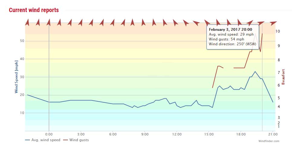
30
December 2016
Brighton
& Hove Albion's match with Cardiff on
Friday night was postponed due to heavy fog on the south coast.
Referee
Chris Kavanagh made two inspections of conditions at the AMEX Stadium before
deciding the game couldn't go ahead around 6
pm.
Sky
Sports Report
9 December
2016
12.5
°C recorded
by the Met
Office at 1:00 pm:
a high temperature for December.
7 December
2016
12.3
° C recorded by the Met
Office at midday:
a high temperature for December.
1
December 2016
The
Met
Office air temperature fell below freezing to -5.3
°C at 6:00
am. There ws a thin layer of ice on my small
garden pond. The day time temperature rose to 8.3
°C, The sea was calm and the River
Adur estuary and Widewater
Lagoon were like a mill pond with what little wind there was blown
in from the north.
30
November 2016
Suddenly
it got cold and it was freezing over night. It did not seem that cold though
and I did not find any ice on the small pond before midnight. There was
ice on the water butt after midday though.
22
November 2016
20
November 2016
Storm
Angus
Storm
Angus
In
the morning, after the gale had receded
Photograph
by Stuart M
Clout
9 October 2016
A gust of 64.5 mph (Force 11) was recorded in the a early hours.Windfinder recorded gusts up to 53 mph (Force 9) at Shoreham Airport.
On a varied cloudy day, the most spectacular Rainbow I had ever seen appeared over Shoreham for 18 minutes in the afternoon. It appeared as both as a double rainbow and even a treble rainbow for a very brief moment.
13
September 2016
Shoreham
Met Office recorded 25.9 °C at
5:00
pm. 23 °C at
11:00 pm.
23
August 2016
The
Shoreham
Beach Weather Station air temperature reached 25.3
° C at 9:40
pm.
Shoreham
Met Office recorded 25.8 ° C
at 5:00 pm.
20
July 2016
Force
5 Gusting to Gale
Force 7 but still too hot to sleep. 25.9
° C at 1:00
am. It also rained.
19 July 2016
Lucky a breeze (Force 4) was blowing as it was very warm > 28.9° C. No clouds were seen in a clear blue sky. (This could be the highest temperature this century?)
18
July 2016
On
the first warm day of the year (Air
Temperature >25.3° C) of
the year, the male Chalkhill
Blue Butterflies (16) finally emerged on the
lower slopes of Mill Hill when I visited
in the middle of the day. The Humidex
was hot >32.1°
C.
Shoreham
Beach Weather Station
12
- 24 June 2016
A
spate of thunderstorms
for almost every day with short spells of torrential
rain.
18 March 2016
Easter Monday started with gales, and at 3:00 am, it was Gale Force 8 gusting to Storm Force 10 (60 mph) from due south, as recorded by Shoreham Met Office.
16
February 2016
The
air temperature fell below freezing around dawn and there was a layer of
ice on standing water.
Gales
blew throughout the day and for a large part of the daylight hours it was
Gale
Force
9 even reaching a steady 65.6
mph (Violent Storm Force 11)
gusting to 67.4 mph with
some very alarming sudden gusts. The wind direction was WSW but sudden
gusts could blew from other directions. These wind speeds were recorded
by the more exposed Shoreham
Beach Weather Station but even Shoreham
Met Office recorded gusts to 61 mph.
The lowest was Gale Force 8 during
the daylight.
| Strong
Gale Force 9
High waves; seas begins to roll; dense streaks of foam; spray may reduce visibility. Very Rough. Storm
Force 10
Windfinder gave the maximum wave height at 5.6 metres. At the time of the photograph it was at 5.4 metres. |
 |
15
January 2016
I
cycled up past Mill Hill into a north wind
on my newly acquired bike, with a wind chill
just below zero.
Extensive
flooding to the north in the low lying fields around Henfield could seen
from the muddy footpath north of and downhill from Beeding Hill car park.
25
December 2015
Christmas
Day
Shoreham
Beach Weather Station recorded an air temperature 13.2°
C, and wind gusts to Gale Force
7. There was rain in the morning.
23
November 2015
Two
Sun
Dogs* (=parhelia) were seen through the
cirrus clouds and over the sea in the afternoon as the sun fell lower in
the sky. Gentle waves rolled across the submerged sand on a low neap tide.
The wind had dropped and Widewater
Lagoon was mill calm with reflections in the weak sunshine, in mid-afternoon.
*Sun
Dogs are a member of a large family of
halos, created by light interacting with ice crystals in the atmosphere.
Sun dogs typically appear as two subtly coloured patches of light to the
left and right of the Sun, approximately 22° distant and at the same
elevation above the horizon as the Sun. They can be seen anywhere in the
world during any season, but they are not always obvious or bright. Sun
Dogs are best seen and are most conspicuous
when the Sun is close to the horizon.
21
November 2015
Windy
and cold, the anemometer
of the Shoreham
Beach Weather Station recorded a
gust of 56.4 mph (Force
10).
In the afternoon the winds died down and after dusk the temperature began
to fall to steadily from a day time high of 6.1°
C to freezing 0°
C by midnight.
19
November 2015
The
anemometer
of the
Shoreham
Beach Weather Station recorded a
gust of 51.4 mph (Force
9).
18
November 2015
A
steady Force 6
throughout the afternoon gusted to 52 mph
(Force 9) at
9:00 pm as measured by Shoreham
Met Office.
The Shoreham Beach Weather Station anemometer was out of action.
Mist over the Adur
River
Adur at Upper Beeding
on
a high spring tide
The distance visible in the photograph above was measured at 400 metres so in common parlance it is mist not fog.
The official definition of fog is a visibility of less than 1,000 metres. This limit is appropriate for aviation purposes, but for the general public and motorists an upper limit of 200 metres is more realistic. Severe disruption to transport occurs when the visibility falls below 50 metres. Useful labels for these three categories are aviation fog, thick fog and dense fog.
Definition
The
term "fog"
is typically distinguished from the more generic term "cloud"
in that fog is low lying, and the moisture in the fog is often generated
locally (such as from a nearby body of water, like a lake or the ocean,
or from nearby moist ground or marshes).
By definition, fog reduces visibility to less than 1 kilometre (0.62 mi), whereas mist causes lesser impairment of visibility.
For aviation purposes in the UK, a visibility of less than 5 kilometres (3.1 mi) but greater than 999 metres (3,278 ft) is considered to be mist if the relative humidity is 70% or greater; below 70%, haze is reported.
28 September 2015
A Lunar
Eclipse was seen in the early hours
of the morning when the Sun, Earth and Moon were in syzygy.
Photographs
taken at 11:19 pm; 2:09 am; 3:25 am; 3:27
am.
22
August 2015
Shoreham
Met Office recorded 26.1° C at
7:00
pm, the second
highest air temperature so far this year. It seemed warmer to me.
13
August 2015
Thunder
rumbled
at dawn and with occasional lightning
(to the south) and continual rain
occurred throughout the morning (5.4 mm).
The bucket water measurement was 100 mm (4 inches).
24
July 2015
It
rained
almost all day and it must have been over
an inch fell. Shoreham
Beach Weather Station recorded 12 mm
(but I am not sure how accurate this is?). My bucket measured 40
mm (inaccurate).
4 July
2015
Shoreham
and Sussex missed most of the thunder and
lightning
and
rain.
Shoreham Beach Weather Station recorded 26.5° C, the highest air temperature so far this year. It seemed warmer to me.
11
June 2015
Shoreham
Beach Weather Station recorded 24.4°
C,
the highest air temperature so far this
year. It did not seem so warm to me.
6 May
2015
.jpg) |
 |
Gales battered the shore throughout the day, a steady Fresh Gale Force 8 gusting to Storm Force 10 was recorded by Shoreham Beach Weather Station. The maximum wind speed recorded was 59.9 mph (Force 10).
8 April
2015
Shoreham
Met Office showed
the air temperature attaining 13.1 °C
at
1:00
pm.
Shoreham
Beach Weather Station recorded 12.4°
C.
6 April
2015
Shoreham
Beach Weather Station recorded 17.0°
C,
the highest air temperature so far this
year. It did not seem so warm to me.
2 February
2015
A
thin layer of ice
was seen on the pond in the morning with over night air temperatures falling
to minus -5.3 °C at
7:00
am & 8:00 am.
Shoreham
Met Office
29
December 2014
There
was just the first thin layer of ice on my garden pond at midday
when the temperature rose above freezing to 2.7
°C,
Shoreham
Met Office recorded air temperatures fell below freezing over night,
down to minus -3.7 °C
at 7.00 am, minus
-3.5 °C at 9:00
am.
14
December 2014
Shoreham
Met Office reported air temperatures fell below freezing over night,
down to minus 4.3°C
at 4:00 am. The
independent Shoreham Beach
Weather Station recorded down to plus
0.3°C. By the end of the following midnight,
the air temperature rose to 10.3°C.
8/9
° 9/10 November 2014
Rumbling
thunder, lightning
and rain
continued through two nights in succession.
11
October 2014
It
rained continually for most of the day, quite hard for a lot of the time.
The rain for the day was measured at 12.00
mm by the Shoreham
Beach Weather Station.
10
October 2014
The
late afternoon and evening hours after dark brought intermittent and then
an hour (7:30 - 8:30 pm)
long continual thunderstorms
and lightning
with torrential rain.
Shoreham
Beach Weather Station recorded 7.2 mm
rainfall, mostly in about half an hour.
9 October
2014
A
steady Gale Force
8 gusted to Force
10 (57 mph) around the middle of the day and
into the evening. Thunder
and lightning
and rain
from about 8:00 pm
but not excessive, but almost immediately overhead my house in Corbyn Crescent,
Shoreham.
7-8
October 2014
The
rain of the two days came in sustained downpours and brief squalls.
7 October
2014
I
was woken in the early hours of the morning by the most ominous and prolonged
rumblings
of thunder I can ever recall. I have heard
louder sudden claps but this was constant for a few minutes or more. Rainfall
for the day was measured by Shoreham
Beach Weather Station at 25.77 mm
with an early morning hourly record of 17.7
mm at 4:47 am.
6 October
2014
The
brief Indian Summer
was curtailed by the first day of rain.
19
September 2014
The
air temperature of the attained 21.4°C
measured by Shoreham
Met Office.
17
September 2014
The
air temperature of the attained 23 °C
measured by Shoreham
Met Office.
16
September 2014
On
a warm (21.7 °C, measured
by Shoreham
Met Office) humid afternoon a Kestrel
swooped over the lower slopes of Mill Hill.
10
August 2014
The
remnants of Tropical Storm "Bertha" dumped rainfall
to the tune of 35.7 mm in
the 12 hours up to midday, peaking at about
10:15
am. 21 mm
fell in one hour. The bucket measured 60 mm
of rain water.
Shoreham
Beach Weather Station
28
July 2014
There
was Rain,
Thunder
and
Lightning
in
the early hours before dawn. The cumulative rainfall in the last two downpours
(including the one on 25 July 2014)
measured 38 mm
by the bucket method.
25
July 2014
My
afternoon visit to Mill
Hill was interrupted by a thunderstorm
and rain deluge that drenched me to the skin.
 23
July 2014
The
highest air temperature of the year (so far) of 28.1°C
was recorded by Shoreham
Beach Weather Station in the afternoon. Shoreham
Met Office recorded 28.2°C
at 5:00 pm. My
indoor temperature gauge recorded 27.6°C.
20
July 2014
The
heaviest
deluge of rain I have ever seen started
at 8:02 pm. It
was still going at 8:07 pm.
It eased at 8:16 pm
but it was still heavy rain and over an inch of extra water was seen in
a bucket (rough measurement at 33 mm)
and my front path doorstep was underwater for the first time recorded.
The thunder and
lightning
was not particularly unusual. The rain eased even more by 8:21
pm and finished shortly afterwards.
18
July 2014
Rain,
Thunder
and Lightning returned
just after 8:00 pm but
the centre was to the east and over the sea.
Rain, Thunder and Lightning started just after 1:00 am. It was unprecedented in frequency of continuous lightning this century from 1:40 am to 2:00 am.
The
Spanish
Plume (Penacho Iberico in Spanish and
Spaanse Pluim in Dutch) is a weather pattern in which a plume of warm air
moves from the Iberian plateau or the Sahara to northwest Europe giving
rise to severe storms. This meteorological pattern can lead to extreme
high temperatures and intense rainfall during the summer months, with potential
for flash flooding, damaging hail
storms and tornado formation. [wiki]
Spanish
Plume (NetWeather UK)
17
July 2014
The
highest air temperature of the year (so far) of 25.4°C
was recorded by Shoreham
Beach Weather Station. My indoor temperature recorded 26.2°C.
Both were recorded at 8:00 pm.
The temperature rose into the early evening and did not fall until 8:15
pm.
24
June 2014
The
highest air temperature of the year (so far) of 24.0°C
was recorded by Shoreham
Beach Weather Station.
8 June
2014
The
highest air temperature of the year (so far) of 21.5°C
was recorded by Shoreham
Beach Weather Station.
24
May 2014
4.3
mm of rain fell in one hour with a time recorded
at 1:23 pm.
Shoreham
Beach Weather Station
| 13
March 2014
Fog rose from the Adur river valley in the late afternoon. The air temperature needed to fall from a high of 14.1°C to the next recorded temperature of 7.5°C (Dew Point 5.5°C) for the fog to be anything more than a distant mist, with the temperature falling to 6.3°C later. Humidity varied between 93% and 95%. The Fog was greatest at sea level but by late afternoon visibility was reduced to 100 to 350 metres (depending on direction) on Mill Hill and the valley below was shrouded in fog. On the River Adur (Surry Hard) the visibility was down to 85 metres. |
 |
10
March 2014
The
air temperature of the year at 16.1°C
recorded
by Shoreham
Beach Weather Station at 2:16
pm was the highest of the year so far.
5 March
2014
The
air temperature of 11.8°C recorded
by Shoreham
Beach Weather Station in the morning was
the highest of the year so far.
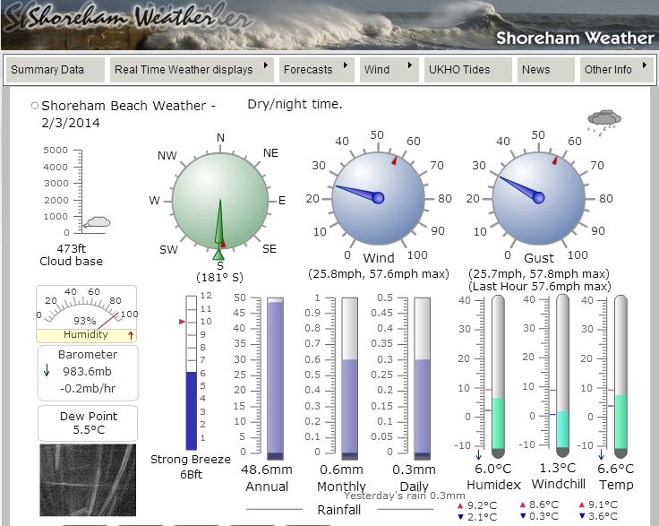
| 2
March 2014
Although only a steady Force 6 in the evening, the weather was still awful with rain, hailstones, and gusts to Storm Force 10. |
 |
| 14
February 2014
Storm The inclement weather returned with continual rain (not heavy) throughout the day and a steady Gale Force 7 to 9 in the evening. Shoreham Beach Weather Station recorded a maximum gust of 70.7 mph (Force 11). The southerly wind, steady to Gale Force 10 (58.9 mph), was fluctuating with the gusts making cycling almost impossible (and I declined this). About11:20 pm a gust of 73.9 mph (Force 12) was recorded by Shoreham Beach Weather Station. The maximum gust recorded in the evening was a 78.8 mph from a steady (for over an hour) Storm Force 10. Previous Force 12 Record Just before midnight a predicted storm surge of 1 metre boosted a 5.9 metre high spring tide with gale force winds. Shoreham Met Office only reports hourly readings and the highest they reported was 66 mph (Force 11). |
.jpg) |
13
February 2014
After
the storms, the
sun made a brief occurrence in the early afternoon,
enough for a Small Tortoiseshell Butterfly
to awake from its diapause
and flutter around a white van at the eastern end of the High Street, Shoreham.
| 12
February 2014
Near Gales and Gales (steady Force 6 to Force 8) blew throughout the day, at some times worse than other times and with persistent rain including deluges, Shoreham Met Office recorded gusts up to 60 mph (Storm Force 10) at 2:00 pm ° 3:00 pm. Shoreham Beach Weather Station recorded a maximum gust of 65.4 mph (Violent Storm Force 11) around the same time. The southerly wind was characterised by very sudden gusts over a relatively low steady wind speed (e.g. 35 to 65 mph). Shoreham Beach Weather Station takes continual readings whilst the Shoreham Met Office only reports hourly readings which may account for higher recordings by the private station. At 4:00 pm Shoreham Met Office recorded a gust of 66 mph (Force 11). |
 |
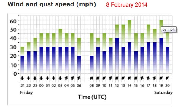
| 8
February 2014
A gale blew intermittently throughout the day with Shoreham Met Office recorded gusts up to 62 mph (Storm Force 10) at 7:00 pm. Shoreham Beach Weather Station recorded a maximum gust of 67.9 mph (Violent Storm Force 11) around the same time. |
 |
| 5
February 2014
As gales battered the coasts of England, Shoreham Beach Weather Station recorded the wind as a Gale Force 8 gusting to Storm Force 10 and it certainly seems like this. Shoreham Met Office only recorded gusts up to 54 mph (Gale Force 9) at 2:00 pm. This wind speed of Strong Breeze Force 6 gusting to Force 9 was constant from before midnight and throughout the day. |
 |
11
January 2014
The
lowest air temperature of 2014
(this winter) was recorded at 0.9°C was
recorded by Shoreham Beach
Weather Station.
January
2014
The
Met
Office reported that for southern central and south-east England it
was the wettest January
since records began in 1910.
It seemed to rain continually throughout the month. The rainfall may have
been the highest for nearly 250 years, The monthly
total was higher than any since 1767
and over twice the average level.
3
January 2014
I
was right in the middle of the new Adur
Ferry Bridge when the the low flying clouds in mid-afternoon were illuminated
by a flash of lightning
followed immediately by one tremendous clap of thunder
and a second clap a few seconds later. I was nearly blown from my bicycle
by a gust of wind and battered by hailstones.
Out at sea it was rough, the waves were
foaming
with white caps like just about a steady Gale
Force
7 from the south-west, blowing diagonally
on to the shore. Grey clouds reached down to the sea and the swirling gust
conditions looked and it felt like a squall (or mini tornado) might form.
The Shoreham Beach Weather
Station figures corresponded to my observations recording a steady
wind speed of 34 mph (Force 7) gusting to
62 mph (Force 10). An earlier gust of 66.8
mph (Force
11) was recorded.
 |
 |
|
|
|
Between
midday
and 1:00 am, the high spring tide
of 6.7 metres plus
a storm surge of
0.4
metres was a possible flood risk that did
not materialise, although the wind assisted waves in the River
Adur estuary splashed on to Coronation
Green, in Shoreham.
|
After
dusk the gale increased and Shoreham
Beach Weather Station recorded steady wind speeds of 45
mph (Gale Force 8) gusting to 73.9 mph (Hurricane
Force 12) before 6:00 pm.
|
| 1
January 2014
The New Year was heralded in by overcast and damp weather. It was not until the early hours that the gales and heavy rain started mostly Gale Force 7 gusting to Storm Force 10, but on occasions reaching Gale Force 8 gusting to Violent Storm Force 11 according to the Shoreham Beach Weather Station which recorded a gust of 66.4 mph (Force 11). The recorded wind speeds certainly corresponded with the large trees swaying constantly in the wind and battered by the rain. Shoreham Beach Weather Station Storm at Worthing (Video by Peter Weever) Three
Herring
Gulls glided in the wind under the fast
moving low flying grey clouds, the first birds seen this year as the rain
stopped in the afternoon.
|
 |
|
30
December 2013
|
 |
25
December 2013 Christmas Day
Thunder
was
heard about 3:00 am. It
woke me up. There were puddles in the road and a clear day at 11:00
am. At 11:20
am it started raining again but it was soon
just a light drizzle. By the afternoon it was quite a pleasant day. A few
buttercups
were flowering in my front garden. The
air temperature rose to 8.7 °C
Shoreham
Met Office
| 23
December 2013
It is very windy, up to a steady Force 8 and it rained continually all afternoon and into the evening. One gust was measured at 69 mph. |
 |
6
December 2013
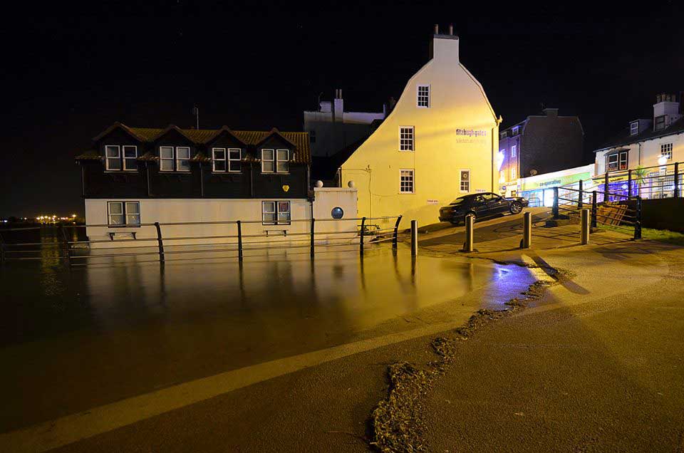
Coronation Green in flood just after midnight. Photograph by Mark Bond on facebook Click on the image for the flood gallery of photographs. |
| 6
December 2013
A Storm Surge put extra height on a high spring tide of 6.5 metres. The predicted tide was over the 7 metres normal maximum and a Flood Warning was issued. |
| 28
November 2013
19.6 mm of rain fell during the day. Shoreham Beach Weather Station 26 November 2013 |
8 November
2013
8.7
mm
of rain fell in one hour with a time recorded
at 9:05 pm.
Shoreham
Beach Weather Station
October
2013
It
was the warmest
October in my
memory.
| 28
October 2013
Gale Force winds blew in hours of darkness until dawn. Shoreham Met Office page recorded a gust of 67 mph (Violent Storm Force 11) at 6:00 am from a steady 45 mph (Force 8). A few trees came down in Shoreham. Shoreham Beach Weather Station recorded 78 mph (Hurricane Force 12). |
 |
 |
Fishing
Vessels at Shoreham Harbour, Sussex
with
Shoreham Power Station
Photograph
by Andy Horton
28
- 29 October 2013
Over
the night and morning, the south coast was battered by a Gale
Force
8, gusting to Storm
Force 10, with exceptional gusts of Hurricane
Force 12 in exposed parts of the coast. The
fishing fleet was moored up for two days and nights in ports all along
the coast, including 20 of the the larger fishing vessels in Shoreham
Harbour.
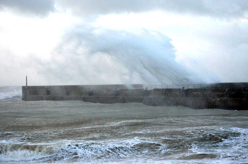 |
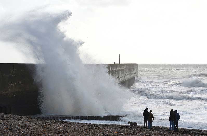
Storm
at Dawn
Western
Harbour Arm, Shoreham
Photographs
by
Mark Bond
| 27
October 2013
A visit to Southwick Beach was blustery with it seeming windier than the recorded Gale Force 7 gusting to Gale Force 9 (49 mph) around 1:00 pm. Shoreham Beach Weather Station recorded 63 mph (Force 10) and I was out in it and it was believable. Shoreham Met Office page recorded a gust of 52 mph (Force 9) at 3:00 pm. |
 |
 |
11
September 2013
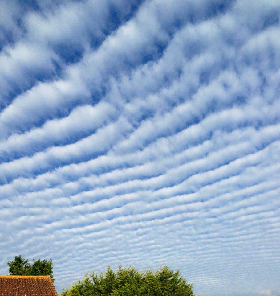
Autocumulus
"Mackerel Sky" Clouds over Lancing in
the early morning.
|
8 September
2013
There
was thunder, lightning
and torrential rain
in the late afternoon (after 5:00 pm),
but it did not last very long, 12 minutes at the most.
6 September
2013
The
warm weather finally broke and the first overcast day for a week and the
end of the summer weather
and the beginning of autumn.
12
August 2013
Stars
could be seen on a dark moonless night
but none of the promised meteors
before midnight,
after which it became hazy.
27
July 2013
At
last the thunder and lightning
begins and there is a small amount of rain at 7:00
pm.
 |
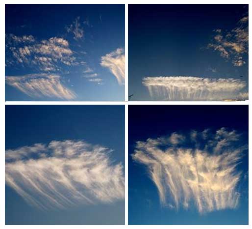 |
CLOUDS
Photographs
by Ray Hamblett
The clouds looked very strange at dusk (8:52 pm) over Lancing and a similar view was seen from Hollingbury, Brighton.
21
July 2013
The
air temperature measured 27.9 °C at
6:00
pm, the equal highest so far this year.
Met
Office: Shoreham
19
July 2013
The
air temperature measured 27.9 °C at
3:00
pm, the highest so far this year.
Met
Office: Shoreham
18
July 2013
The
air temperature measured 27.7 °C at
4:00
pm, the highest so far this year.
Met
Office: Shoreham
7
July 2013
In
the warmth of the midday
sun the air temperature measured 26.4 °C
at
1:00
pm.
6 July
2013
Warm
at last with the sun out all day: 22.3 °C
at 3:00 pm with
little or no wind.
13
June 2013
White
caps could be seen on breaking waves on the River
Adur by Coronation
Green in Shoreham. Just over a week before
the Summer Solstice and the WSW wind blew a steady Force
6 gusting to Gale Force
8.
Met
Office: Shoreham
8 June
2013
A
fine
Adur World Oceans Day with the sun out
throughout. It felt like the warmest day of the year.
31
May 2013
Warm
at last when the sun came out: 21.2 °C
at 5:00 pm.
6 May
2013
Cherry
blossomed and shirt sleeved weather (13.3°C),
the only white in a bright blue sky was a vapour
trail. This air temperature was probably
the highest of the year so far, the previous high
being a recording mistake.
14
April 2013
The
air temperature reached a high of 16.1 °C
at 4:00 pm. This
was easily the highest of the year so far.
This reading was a sudden peak
(this reading
seems like an anomaly.) and the air temperature
mostly registered about 13.0 °C.
Met
Office: Shoreham
10
April 2013
12.4
mm of rain
fell
during the 24 hours up to 10:00 pm.
But all of it fell between 7:00 pm
when I started my Mill Hill talk
at Lancing Manor and 11:00 pm when
I got home (by car).
2 April
2013
For
just a few minutes I felt he brief and weak warmth of the sun from between
the white clouds, as I was battered by a chill north-east breeze (Force
5 gusting to Force 6). The air temperature
reached 7.4 °C.
12 March 2013
The snow slowly melted during the day but not all of it, and the melted snow froze making some shady areas perilously slippery. Gusts of wind blew the powdery snow around and this effect could be seen at a distances e.g. on Mill Hill from Shoreham Beach.
 |
 |
|
|
|
11
March 2013
5
cm of snow fell after dark but it stopped
before midnight.
| 18
January 2013
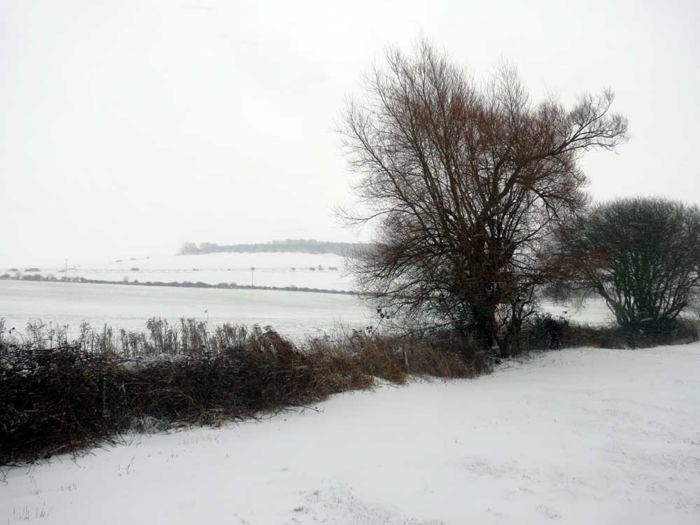
Snow blew vertically in from the east (Force 4) during daylight. Around midday the snow was an inch (25 mm) deep on the cold ground in Shoreham with the air temperature only just below freezing. On the cyclepath north of Old Shoreham the depth of snow was measured at 60 mm. The snow stopped about 2:00 pm. |
 |
16
January 2013
After
midnight (1:00 am)
the air temperature was recorded at minus
3.9 °C, the coldest so far this year.
15
January 2013
In
the early evening (8:00 pm)
the air temperature was recorded at minus
3.8 °C, the coldest so far this year.
Met
Office: Shoreham
|
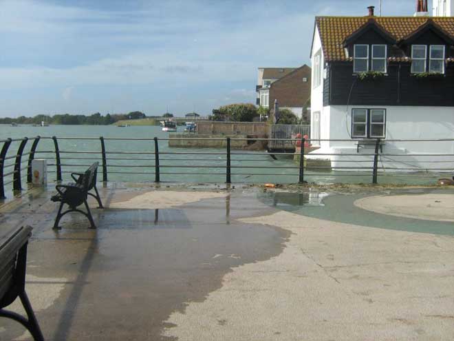
25 December 2012 Christmas Day The trees were swaying in the wind and I could hear the howl of the wind between the houses and down the chimney. At 11:00 am the gusts were Gale Force 8, (recorded 41 mph at 10:00 am). It was recorded at a steady Force 6, but the gusts seemed to be continuous. |
 |
17
October 2012
A Storm Surge put extra height on an exceptionally high tide of 6.8 metres at 12:56 pm, just beginning to flood Coronation Green. The forecast surge height was 0.33 metres. Storm Surge Forecasts (National Oceanographic Centre) |
15
October 2012
WithCumulus
clouds
rushing across the sky, the weather was changeable, the sun shining through
the gaps in the clouds for a few minutes on the lower slopes of Mill
Hill, and I was subsequently battered
by hail
blowing horizontally (Force
4) from the west when I trekked across
the upper plateau. A male Kestrel
hovered over Mill Hill,
silhouetted by the changing
cloud types. Flowers
were scarce and most had turned to seed. Dogwood
leaves had turned to a dark red and there was the feel
of autumn with the fallen leaves under
foot.
23
- 25 September 2012
Heavy
rain through three days and some after darkness.
 |
5
September 2012
Mare's Tails, Cirrus uncinus, usually precede fair weather. |
26
August 2012
My
overall memory of this wet and cool summer, will not be the rain and varying
temperatures, mostly cool, but of the almost constant Breeze. It was blowing
a steady Force 5
(22 mph) in the afternoon as I wrote this.
The bushes of Buddleia
and the butterflies
were being blown about and the wind gusted up to Force
6 (29 mph). The temperature was a pleasant19.9
°C.
Met
Office: Shoreham
22
July 2012
At
least the clouds have dispersed and the sun shines and the butterflies
appeared as it warmed up in the early afternoon to a below average 17.8
°C.
8 -
21 July 2012
The
cool breezy weather continues with showers.
Jet
Stream Explanation
5 -
7 July 2012
Rain
occurred intermittently throughout the days and nights but in other parts
of England, floods occurred.
Floods
on other parts of the UK
June
2012
The
Met
Office reported the wettest June
for over a century.
"Provisional
Met Office figures for June show double the average amount of rain has
fallen, making it the wettest June since records began in 1910.
This
is the second record breaking month of rainfall this year, with April also
topping the rankings. The period from April to June is also the wettest
recorded for the UK.
It
is also the second dullest June on record with just 119.2 hours of sunshine,
narrowly missing out on the record of 115.4 hours set in 1987. To complete
the disappointing picture, it has also been the coolest June since 1991
with a mean temperature of 12.3 °C.
Movements
in the track of the jet stream, a narrow band of fast flowing westerly
winds high in the atmosphere, have contributed to the weather we have seen."
(Extract)
21
June 2012
More
bad weather occurred either side of the Summer
Solstice with breezes gusting to gales
and cool temperatures. (The records were kept
but they have been misfiled.)
10
- 11 June 2012
The
awful weather continues, this time with a deluge of rain in the
south-east of England with the worst recorded at Shoreham
weather station, with 24.6
mm recorded in 24 hours up until the end end
of 10 June 2012,
and according to BBC Radio
5, 55 mm
fell in Shoreham over night. Later BBC (SE)
TV stated the figure for Shoreham was 58 mm.
 8
June 2012
White
caps appeared on the waves driven diagonally across the River
Adur from the WSW in a constant Gale
Force
7, gusting to Storm
Force 10, constantly throughout the day without
remission. Batten down the hatches and stay indoors, but we had to be out
in this weather setting up Adur World Oceans Day
2012 in the marquee on the exposed Coronation
Green, Shoreham. The wind hammered at
the marquee all day until we were driven to despair by the constant noise.
Waves from the south-west battering the Shoreham
Harbour wall
Photograph
by Alec Trusler
Beaufort
Scale
Met
Office: Shoreham
25
May 2012
The
sky was completely blue without any trace of a cloud. It was warm (25.9
°C
at
1:00
pm was the warmest this year) and breezy (Force
4) with strong easterly gusts (Force
7), rising to 26.0
°C at 2:00
pm, and to Force
5 at 3:00 pm.
22
May 2012
It
was easily the warmest (the first air temperature recorded in excess of
20
°C in the hour
before midday, rising to 24.9
°C at
5:00
pm)
day of the year so far with the wind (Force
4 blowing from due north). It felt a bit
sticky.
27
March 2012
With
no cloud cover to keep in the heat, the air temperature fell over night
to 4.9° C
at
7:00
am
26
March 2012
The
air temperature in the sunshine under an azure blue sky recorded at 19.0
°C at
3:00
pm, the highest of the year.
24
March 2012
The
air temperature recorded at 17.6 °C at
11:00
am. This is the highest so far this year that
I have noted.
23
March 2012
The
sunshine came out in the afternoon and it felt quite pleasant, but the
air temperature only reached a maximum of 14.9
°C.
By
the red sunset
(6:19 pm), the fog
began to roll in at the entrance to Shoreham Harbour
where the end of the harbour piers were obscured from a viewpoint by the
Lifeboat
Station on Kingston Buci Beach. The
spring tide (forecasted 0.7 metres) had receded
to the Chart Datum mark.
In the night
sky (7:00 pm)
to
the east Mars
shined,
Sirius
twinkled
to the south, and in the west,
Venus shone
brightly immediately above Jupiter.
22
March 2012
The
air temperature recorded at 16.3 °C at
5:00
pm and may have been higher earlier in the
day and this was probably the warmest temperature of the year.
Met
Office: Shoreham
12
March 2012
Under
a blue sky and weak sunshine (14.6
°C) the Sweet
Violets were flowering on Mill
Hill, where I saw two Peacock Butterflies
(my first two butterflies of the year), one
flying across the road at the top of the hill and another one fluttering
over the lower slopes. In the mid evening (9:00
pm) it was foggy.
The
flood equinoctial spring tide was one metre above
Chart
Datum at 9.00 pm
and one hour after low water. The fog lasted for about an hour.
Adur
Butterfly List
Sea
Temperature UK: 13 March 2010
UK
Sea Temperature Map
Fog
Information
23
February 2012
The
sun came out in the afternoon and the air temperature rose to 14.2
°C at 1:00
pm.
12
February 2012
It
was a cold night throughout with the air
temperature falling to minus 5.6 °C,
below minus 5.0 °C from
1:00
pm to 6:00 pm.
10
February 2012
The
air temperature fell to minus 6.4 °C
at 7:00 am (the
coldest of the year).
7 February
2012
It
was forecasted to be a cold night with the air temperature already below
freezing (minus 0.9 °C)
at 5:00 pm. The
lowest recorded at 10:00 pm was
minus
3.6 °C, but it remained below freezing
all night and only rose a fraction above freezing throughout the morning.
.
5 February
2012
It
is just above freezing in Shoreham town and damp but no snow, but I can
see a thin layer of snow on the downs from my top floor window at
midday.
4 February
2012
The
air temperature was minus 5.3 °C
at 8:00 am. At
8:00
pm there was a thin layer of snow of about
2 mm on the pavement. By 10.00 pm
it had all melted and it rained.
3 February
2012
The
air temperature was minus 5.4 °C;
that's five below zero at 3 o'clock in the
morning. I had to go out and post the VAT
form. There was no wind (Force
2 from the north) but it sure felt chilly
out there, all wrapped up. It was not damp though. No snow was expected.
The air temperature fell to minus 6.3 °C
at 8:00 am (the
coldest of the year so far).
Met
Office: Shoreham
Lowest
Temperatures this Millennium 2010
2 February
2012
At
dawn (7:00 am)
the air temperature was recorded at minus
2.6 °C, the coldest so far this year.
Met
Office: Shoreham
 3
January 2012
It
was a horrible morning with sheet rain and gales from the south-west, reaching
a steady Gale Force 8
from 10:00 am to midday and after,
and gusting to Storm Force 10 (59 mph)
from 11:00 am.
Beaufort
Scale
Met
Office: Shoreham
| 25
December 2011
The weather was dry and mild for the time of year, with a steady 10 °C throughout the day and a Gentle Breeze (Force 3). |
 |
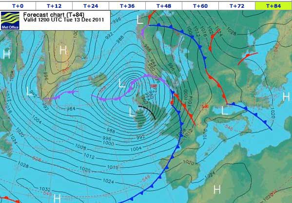
| 12-13 December 2011 Midnight |
 |
| 12
December 2011
In the evening between 11:00 pm and midnight there was a steady just about Gale Force 8 (39 mph) but an occasional exceptional gust (62+ mph) to Storm Force 10 rattled even closed windows. Met Office: Shoreham |
 |
20
November 2011
A
photograph of the mist/clouds over the Adur
Valley viewed from Mill
Hill was shown on BBC
South Today. The low lying clouds hung so low that Lancing
College could be seen rising out of them.
Images
by Dave Saunders Graphics (Link)
22
October 2011
It
was a virtually cloudless sky with just a few fluffy patches of Cirrus
exceeded in quantity by a few vapour
trails, at an air temperature of 12.3
°C.
 3
October 2011
Out
in the hazy sun shone as it was forecasted to be the last warm day for
several months. The air temperature reached 20.5
°C at 3:00
pm with the breeze blowing from the south-west.
1 October
2011
My
thermometer recorded 24.5 °C
in the shade at 1.00 pm
whereas the official air temperature recorded
23.0 °C at 1.00
pm.
Met
Office: Shoreham
Record
October Temperature in Kent
28
September 2011
Under
a clear blue sky, the proximity of the colder sea may have limited the
air temperature to a maximum of 21.1 °C(the
lowest maximum in the south-east, Gravesend recorded 27.1 °C).
27
September 2011
The
day was not as sunny as forecasted and in the late afternoon a fret
(sea mist) obscured the Shoreham Harbour Power
Station chimney when viewed from Dolphin Road in Shoreham.
The air temperature was 16.0 °C
at 5.00 pm when
the fret occurred. Before the fret the air temperature at 3.00
pm was 17.9 °C.
The
south-east
wind speed was 7 mph.
A set fret occurs when when a parcel of warm air passes over the colder
sea.
BBC
Sea Fret Page
12
September 2011
As
northern Britain is battered
by gales in the wake of Hurricane
Katia, the conditions at Shoreham were
possible for cycling in when
the wind dropped, reaching Force
6 gusting to Force 8 (44 mph) WSW
at 18.9 °C. Whitecaps
formed on both the River
Adur at high tide
(adjacent to the Airport) and just off the coast
where the south-westerly wind direction was apparent from the alignment
of the
waves.
6 September
2011
That
gust was too dangerous to cycle in: Gale
Force 7 gusting to Force 9 (52
mph), but only twice in my life have I seen
anything like a gust lasting for just a second (and once I was blown off
my bike whilst walking it). This could be a gust to Storm
Force 10 as reported on the BBC
South Weather News (where they included a gust of 86
mph, Force 12,
at the Needles
on the Isle of Wight).
Met
Office: Shoreham
15
July 2011
"St
Swithin's Day, if it does rain
Full
forty days, it will remain
St
Swithin's Day, if it be fair
For
forty days, t'will rain no more"
It
rained.
14
July 2011
An
Earthquake
of 3.9 magnitude (depth 10 km, poorly
constrained) was felt in Shoreham
at 7:59 am (not
by me). Its epicentre was 89
km (55 miles) SSW of Brighton,
10 km under the English
Channel.
26
June 2011
Thunder
over
Shoreham and simultaneous flashes of forked
lightning every minute at 2:00
pm onwards. Not much rain at first, but large
drops. Appreciable rain
started at 2:10 pm. but
stopped by 2:16 pm.
There was a couple of minutes of hail around 2:45
pm.
26
June 2011
The
sun burnt off the early morning mist (which obscured Mill
Hill in the mid-morning). At 1:00
pm the air temperature was 17.0
°C
but by 8:00
pm it rose to
24.1 °C.
8 June
2011
It
was still blowing a Force
5 all day, this time from the south-west.
4 June
2011
It
was warm and blustery, the warmest day
of
the year so far recorded at 25.8 °C
at
3:00
pm, but again spoilt by steady Strong Breeze
(Force 6) from the north-east gusting to Gale
Force
7 all through
the day. North of the Toll Bridge,
Old Shoreham, the north wind was causing frequent whitecaps at high tide.
3 June
2011
It
was an almost perfect blue sky with a few streaks of wispy Cirrus
clouds and a pleasant 23.5 °C
which was the the warmest day of
the year so far, spoilt by steady Strong Breeze (Force
6) from the north-east gusting to Gale Force
7 in the afternoon.
Met
Office: Shoreham
25
May 2011
Under
a wispy Cirrus streaked
blue sky it was a steady Strong Breeze (Force
6)
gusting to Gale Force
8 in the middle of the day. Throughout the
afternoon the rain Cumulus
clouds moved over and the Strong Breeze continued mostly throughout, increasing
to a steady Gale Force 7
before reducing to Force 5.
There were brief and heavy rain showers, and regular gusts to 45 mph (Force
8). The moderate
to large waves blowing in from the south-west were topped by whitecaps.
 |
 |
|
|
|
23
May 2011
For
one day the wind dropped under a Cirrocumulus
blue sky.
22
May 2011
It
was far too breezy (a steady Force
6) to photograph flowers.
24
April 2011
Easter
Sunday was
the
warmest day of
the year so far, reaching 22.8 °C
at
both
2:00 pm
and 3:00 pm,
the same as the previous day but for a longer period of time.
23
April 2011
Advection
fog set in over the sea at Lancing
(east Widewater) as the tide turned and the visibility
was diminished to under 50 metres at 10:30
am. It was the warmest
day of the year so far, reaching
22.8
°C at
midday.
21
April 2011
It
was the warmest day
of the year so far, reaching 21.1 °C
at 1:00 pm.
20
April 2011
It
was the first warm day
of the year when the air temperature at midday
reached a qualifying 20.3 °C
under a clear blue sky.
Met
Office: Shoreham
7 April
2011
The
sun shone throughout the day and the air temperature reached 18.8
°C, the highest of the year so far.
22
March 2011
The
sun appeared and the air temperature reached 15
°C.
8 March
2011
There
was a thin layer of ice on my garden pond all morning, followed by the
sunniest afternoon so far this year which an air temperature reaching an
estimated 11 °C.
3 -
6 March 2011
There
was a noticeable chilly easterly breeze throughout the daylight hours,
but my garden pond was not frozen over at dawn.
7 January
2011
The
first rays of sunshine of the year occurred for about an hour around midday.
4 January
2011
Low
clouds obscured a partial Solar
Eclipse which occurred in Sussex after
the sun rose over the horizon between 8:00
am and 9:30 am.
