ELECTRONIC
NEWS
BULLETIN
FOR
THE
ADUR
VALLEY
| News & Events |
| Wildlife Reports |
| Words of the Week |
| Historical Snippet |
| Advertisements |
If
you wish to receive this Bulletin, please ask by EMail, specifying the
Adur
Torpedo with your full name.
Glaucus@hotmail.com |
| Web Sites (Local) |
| Poem |
| Computer Tips |
| Games & Leisure |
| Web Sites (****) |
| Events |
|
|
| Adur
"World Oceans Day"
SLIDE SHOW 2000 |
 |
| Wildlife Web Sites |
 |
| LOCAL
ORGANISATIONS |
| LOCAL RESIDENTS PAGE |
|
|
|
|
|
|
|
|
|
|
|
|
|
|
|
|
|
|
|
|
|
|
|
|
|
|
|
|
|
|
|
|
|
|
|
|
|
|
|
|
|
|
|
|
|
|
|
|
|
|
|
|
|
|
|
|
|
|
|
|
|
|
|
|
|
|
|
|
|
|
|
|
|
|
| 55 | 56 |
This is the first published
Electronic Newspaper for
Shoreham-by-Sea and District,
West Sussex, England
- Local
News
14
February 2001
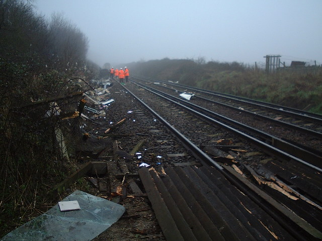
A train hits a van at an
unmanned railway crossing near Shoreham Airport and is badly derailled
with a few minor injuries to train passengers and a disruption to train
services that will last for the whole of 15 February 2001.The van driver
was thrown clear by the impact of the train and suffered bruises and minor
injuries.

The van was carried 100 metres
up the track by the train (1402) travelling at 50 mph. The van was so wrecked
it was unrecognisable.
The track is expected to
reopen at 6:00 pm on 16 February 2001.
National Floodline, Tel: 0845 988 1188
Weather Forecast
Please send any comments to: Andy Horton
Glaucus@hotmail.com
- 12
February 2001
Two badly decomposed Dolphins have been washed up on Shoreham beach. They were so badly decomposed that it is unknown whether they are Common or Bottle-nosed Dolphins.
10
February 2001
Ray
Hamblett reports a Red Admiral
Butterfly from his garden in south Lancing.
10
February 2001
The first Common Frog
entered a pond in The Drive, Shoreham, which was certainly a prelude to
spawning.
8 February
2001
After
several days of rain; the ground is saturated everywhere, especially Lancing
Ring. West
Way, Lancing was flooded, as expected up to the edge of the gardens, but
this is still not as bad as it has been in the past.
National
Floodline, Tel: 0845 988 1188
Empty egg cases of the Thornback Ray (left) and Dogfish (right) are found washed up on the strandline by Andy Horton and Ray Hamblett.
29
January 2001
Adur
World Oceans Day 2001
The
first meeting to discuss arrangements for this Adur Festival event.
Please
express any interest to:
Andy
Horton (British Marine
Life Study Society)
Glaucus@hotmail.com
or
Natalie
Brahma-Pearl (Adur District Council)
natalie.brahma-pearl@adur.gov.uk
Adur World Oceans Day 2000 web page
Lancing
Nature & History - January Newsletter
(Link
to the web site by Ray Hamblett)
- National
Floodline, Tel: 0845 988 1188
Wildlife
Records on the Adur eForum (you have to join)
1 August
2000
The
Marine Wildlife of the North-east Atlantic (formerly
the British Marine Wildlife Forum)
***** commences.
PLEASE
JOIN

MARINE WILDLIFE of the NORTH-EAST ATLANTIC EFORUM PAGE |
UK Wildlife eGroups Forum
http://groups.yahoo.com/group/ukwildlife
Designing for Cyclists (Web Site) Camden Cycling Campaign
After discussion on the Urban Cyclist EForum, it appears that most cyclists have grave reservations about the Camden initiative. There seems to very few advantages to cycle lanes and it may be better if the concept is abandoned altogether.
1 December 2000

UK Environment and Planning EFORUM PAGE |
British
Naturalists' Association (link)
Find
the Sites of Special Scientific Interest using this link:
Friends
of the Earth SSSI Navigator
Words of the Week
prosopography | prs()prfi | n. M16. [mod.L prosopographia, f. Gk prosopon face, person: see -GRAPHY.] 1 Rhet. = PROSOPOPOEIA 1. rare. Only in M16. 2 A description of (esp. the outward appearance of) a person. obs. exc. as in sense 3 below. L16. 3 A description of a person's appearance, personality, social and familial connections, career, etc.; a collection of such descriptions; the study of these, esp. in Roman history. E20.prosopographer n. M20. prosopographic, prosopographical adjs. of or pertaining to the method of historical study or research which makes use of prosopography M20. prosopographically adv. L20.
---------------------------------------------------------
Excerpted from
The Oxford Interactive Encyclopedia
Developed by
The Learning Company, Inc. Copyright (c) 1997 TLC Properties Inc.
Computer Tips
- Computing
Net Support Site
(for computing problems) ****
-
Star:
Latest Virus Information
- Sussex Web Sites
http://computing.net/windows95/wwwboard/wwwboard.html
The upsurge of EFora
on all subjects (a
few have been recommended before in these bulletins) are an important way
in which the Internet
will change the world.
A list of recommended eFora
will appear soon. Please make any suggestions.
See the Profusion Search method below.
Poem of the Week
I
command to depart from me the mermaids who are called the sirens, and also
the Castalian nymphs, that is to say the mountain elves who dwelt on mount
Helicon.
- Water
Music (Piano Retailer) High
Street, Shoreham-by-Sea
Link to their web site.

ADUR VALLEY EFORUM PAGE |
Historical Snippets
Andy
Horton asked some time ago (14-1) where Cymenesora was- Aelle's
supposed
landing-place (Anglo-Saxon Chronicle- date 477).
According
to the Anglo-Saxon Chronicle (AD 477) three Saxon ships arrived in a part
of Britain which was to be later known as Sussex at a place called Cymenes
ora. King Aelle (d. c. 514) accompanied by three sons Cymen, Wlenca and
Cissa landed from Gaul (France). In 465 (485) they fought the British at
what is probably a boundary stream called Mearcredesburna.
------------------------------------------------------------------------
From
John Mills, Archaeologist
West
Sussex County Council- County Planning
There
is a useful discussion of the location in Anglo-Saxon Charters VI -
"Charters
of Selsey", ed. SE Kelly, British Academy, pub. OUP, 1998 - page 12.
Copy
in West Sussex Record Office, Chichester.
"Cumeneshore",
which Kelly identifies with Cymenesora, is mentioned in one of
the
Selsey Abbey Charters, a supposed grant by Caedwalla of Wessex to Bishop
Wilfrid
in 673 (?for 683) of 55 hides in and around Selsey, "seal island", south
of
Chichester.
Like
a number of the supposed early charters, this one is in fact much later
in
date,
though incorporating earlier material. Kelly suggests that this and
another
charter for a grant of land in this area were based on a later 8th-century
original, which itself contained genuine material. This charter, however,
was probably drawn up in the 10th century - and the boundary clause which
mentions Cumeneshore is probably of the same date. The charter was probably
drawn up to strengthen Selsey's sometimes rather dubious claims to land
in the Selsey area - in dispute with perhaps equally dubious claims by
the Archbishopric of Canterbury, to whom the manor of Pagham belonged in
the Middle Ages.
Kelly
mentions that there have been doubts about the Cumeneshore reference being
genuine-
could it have been an invention by a 10th-century scribe?- but is convinced
that the boundary clause, while certainly not of the 670s or 680s, was
perfectly straightforward in 10th-century terms. The names needed to be
genuine - this was intended to be legal document and the bounds of the
land had to be identifiable from contemporary names and landmarks in Selsey.
The
relevant part of the boundary clause states that "from the entrance of
the
harbour
which is called in English Wyderinges [Pagham Harbour]" the boundary ran
along
the coast to "Cymen's bank or foreshore [ora]". Cumeneshore is thought
to
have
given rise to the name of The Owers, a series of now offshore banks
extending
out from Medmerry Farm in Selsey parish. Then the bounds turned
towards
Rumbridge (alias "thri beorg"- three barrows), a lost name in Wittering
and
on the Earnley boundary- also very interesting to the archaeologist!
The
shoreline on the west side of Selsey "island", where Medmerry is located,
has
been eroding steadily over centuries, and is still actively eroding. By
the
16th
century earlier ancient landmarks here could no longer be identified.
Of
course, if the Cumeneshore= Cymenesora identification is accepted, it still
does
not mean that Cymen son of Aelle or Aelle himself, King of the South
Saxons,
actually landed here!
Following the "Cymenesora" string (Andy Horton):
The
medieval "Port of Wythering"- generally identified with Pagham Harbour,
and
the
lost medieval "new town" of Wardour in Sidlesham- also probably on Pagham
Harbour-
represent interesting research subjects in their own right.
Wardour
and the Port of Wythering are both referred to in Julian Munby's paper
on
"Saxon Chichester and its Predecessors" in J Haslam, ed. Anglo-Saxon Towns
in Southern England, 1984- pp. 321-2, 329. See also Maurice Beresford on
Wardour in New Towns of the Middle Ages, pp. 209, 497.There was a hamlet
caled Wardour
Green,
SE of Sidlesham, shown on a map of 1755.
Another of the Selsey charters, of similar origin to the one I have previously referred to, mentions lands in Pagham, with reference to the brethren of St Andrew's church, located on the eastern shore of the harbour which is called Uedringmutha- thought to be the still-extant 10th-century remains of St Andrew's chapel on the east side of Pagham Harbour, not far from the medieval church of St Thomas.
Hope the above is of use
John
Mills, Archaeologist
West
Sussex County Council- County Planning
From:
"John Mills" <jmills@westsussex.gov.uk>
Another
answer is, in part at least, place-names. A pertinent study is "The Anglo-Saxon
Traveller" by Ann Cole in Nomina vol. 17 (1994); she has produced a series
of related articles (see esp. the English Place-Name Society Journal vols
21, 22, 24 & 25), and her hypothesis concerning the function of names
containing Old English _ofer_ and _o:ra_ ('a flat-topped ridge with a convex
shoulder') as travellers'
guides
receives useful discussion and illustration in the new book by Margaret
Gelling & Ann Cole "The Landscape of Place-Names" (2000), pp.199-210.
Note that this element is not found with the meaning 'landing place for
boats'. There's no obstacle to connecting the 'Cumeneshore' of BCS 64 (Sawyer
232: a 13th c. MS) with the 'Cymenes ora' of the A-S Chronicle s.a. 477.
We may readily allow for the
intrusion
of inorganic 'h' in document of this date, and a West Saxon reflex 'u'
of Old English 'y' is unexceptional. More problematic, though they appear
to have received no scholarly comment, are the forms 'cymeneres horan'
and 'cimeneres horan' in BCS 997 (Sawyer 1291: 14th/15th c. MSS) as quoted
by Kelly in "Charters of Selsey" (pp.85-91) - contrast Mawer & Stenton
"The Place-Names of Sussex"
pp.83-4.
I can't believe she made them up, but that extra syllable seems to have
escaped the attention of any other commentator.
Humbly,
Paul
From:
paulcu@cogs.susx.ac.uk
>From:
Andy Horton <Glaucus@hotmail.com>
>Subject:
[sussexpast] Saxon
Signposts
>
>Anybody
fancy pointing me in the right direction to answer the
>following
question:
>How
did the Saxons navigate across land (on on their roads, what did
>they
use instead of signposts and service stations?) ?
>Ideally,
somebody has written a book, even though it may refer to
>earlier
groups, Romans or even earlier people, preferably in Britain
>or
Europe.
>
>Andy
Horton.
1)
It does seem that Cymenesora near Sidlesham has the greatest claim to
the
landing location of Aella and his crew.
2)
"Landing place for boats" for õra (_o:ra_) was creative writing
on my part, with just a shred of old research. Best ignored.
3)
When navigating by land, I am inclined to look for specific signposts or
else I would get lost. I a poor navigator.
4)
The Gelling book is very interesting. Best to order the new book through
the Library system as I have got the first version out on loan.
There
are other things I can ask about this interesting history, but I will
have
a think first.
Cheers
Andy
Horton.
Shoreham.
Sussex
Archaeological Society
http://www.sussexpast.co.uk
Sussex
Archaeological Society EGroup
http://groups.yahoo.com/group/sussexpast
Events
Ropetackle
Ropetackle
Development: Community Group Consultation with SEEDA
Shoreham-by-Sea
This
takes place on 20 February 2001
at the Adur Civic Centre. If you are interested please let me know.
There are places available under the auspices of the BRITISH
Marine Life Study Society. If you want to attend, please ask me at
the earliest possible opportunity as the number of representives are limited
by space.
- Adur
On-line Events page
- http://appspace.nexus-solutions.net/arc/asp/diary/diaryoutput.asp
- Please send in any details of local events.
- SPONSORSHIP OPPORTUNITY
For any company or organisation wanting nationwide green publicity, there is an opportunity to sponsor the journal "Glaucus" of the British Marine Life Study Society.
There remains sponsorship opportunities on the BMLSS (England) web site and other publications, including Torpedo.
Sponsorship is also available for the Adur Torpedo Electronic News Bulletin and the Shoreham-by-Sea web pages (which preceded the Adur Resource Centre web site), which would be more suitable for a local firm(s).
Web Site Design Services are available from Hulkesmouth Publishing
Normal
advertisement rules apply.
Submissions
accepted by EMail only.
Adur
Torpedo was written, designed and distributed by Andy
Horton.

